1. Introduction
Samos is one of the Islands of Greece located south of Chios on the Western end of Turkey, as shown in Figure 1. On 30th October 2020, Samos experienced an earthquake of 7.0 magnitude1. The quake led to the destruction of property and loss of lives based on how it later caused a strong tsunami and permanent ground deformation, leading to a change in the shoreline.
1.1 During and After the Samos Earthquake
The Samos earthquake was the deadliest earthquake that occurred in 2020. Foreshocks were recorded three months before the disaster, indicating the likelihood of a major earthquake to happen1. The island, which is found in a seismically active region, has been facing earth tremors, and the disaster had a probability to occur. Plate movements within the area covered by Samos regularly undergo subduction and, in the process, cause shallow crustal earthquakes, which was the same case as the Samos earthquake event1. The Eurasian, African, and Arabian plates react with the Anatolian plate, which easily triggers earthquakes within the region of the Aegean Sea that covers Samos and parts of Turkey, as seen in Figure 2.

Figure 1. A map showing Samos Island, which was affected by the earthquake.

Figure 2. A map showing the plate within the Samos Island region.
Samos earthquake, being a natural disaster, was considered a catastrophe because of how it was a significant misfortune that led to the death of many people and serious environmental damage. With a magnitude of 7.0, the earthquake made most buildings collapse, and this heavily affected the people living within Samos2. One hundred seventeen people lost their lives as a result, and 1,034 ended up injured in the catastrophic event. Tsunami formation was part of the main events, and it arrived 15 minutes after mainshock2. It reached heights of 1.9m on the coast of Samos and surrounding areas. Based on how there was serious environmental damage to the residential and commercial buildings as well as the loss of many lives, the tragedy was classified as a catastrophe, and this required emergency support to help rescue lives. Some people were even left homeless since their place of living was destroyed.
After the event, rescue operations took place to help the affected individuals, especially in residential buildings with occupants. Over 2,800 aftershocks were recorded, lasting almost three weeks across different regions with a magnitude of 4.4 on the Mercalli intensity scale1. The Coast of Samos was raised by as much as 10 cm based on reports by NASA, and some parts subsided, showing the effects of the earthquake.
2. Comparison
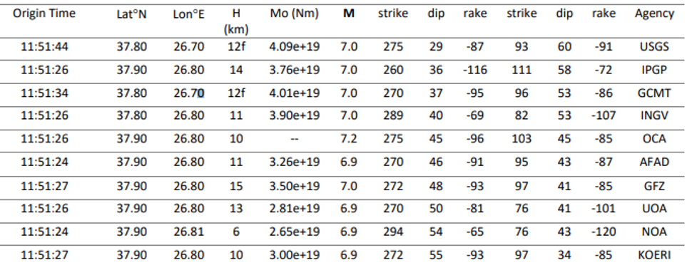
The event of the Samos earthquake could be compared with other events with a similar magnitude of 6.5-7.0, such as the Izmir earthquake, which occurred in Turkey, as seen in Table 1. The earthquake, which occurred in 2017, resulted in 114 deaths, showing how it had significant damage, thus being classified as a catastrophe as well3. The similarity comes from the event’s intensity and how it caused significant damage to property and the loss of many lives.

Table 1. The magnitude of the Samos earthquake
3. Catastrophe
The Samos earthquake was a catastrophe based on how many lives and properties were lost, creating serious environmental damage. A calamity is a natural, violent, or tragic event with significant damage or destruction4. The Samos event led to destruction, where 15,000 were left homeless. 1.30 people were injured, and 117 people died after more than 700 buildings collapsed as a result of the destruction of the violent natural event, showing how it was significant2. Therefore, this classified it as a catastrophe based on the extent of the damage and the cause.
Reference
1Cetin, K.O., Mylonakis, G., Sextos, A. and Stewart, J.P., 2022. Reconnaissance of 2020 M 7.0 Samos Island (Aegean Sea) earthquake. Bulletin of earthquake engineering, 20(14), pp.7707-7712.
2Papadimitriou, P., Kapetanidis, V., Karakonstantis, A., Spingos, I., Kassaras, I., Sakkas, V., Kouskouna, V., Karatzetzou, A., Pavlou, K., Kaviris, G. and Voulgaris, N., 2020. First results on the Mw= 6.9 Samos earthquake of 30 October 2020. Bulletin of the Geological Society of Greece, 56(1), pp.251-279.
3Tiryakioğlu, İ., Aktuğ, B., Yiğit, C.Ö., Yavaşoğlu, H.H., Sözbilir, H.A.S.A.N., Özkaymak, Ç., Poyraz, F.A.T.İ.H., Taneli, E., Bulut, F., Doğru, A. and Özener, H., 2018. Slip distribution and source parameters of the 20 July 2017 Bodrum-Kos earthquake (Mw6. 6) from GPS observations. Geodinamica acta, 30(1), pp.1-14.
4Kheirizadeh Arouq, M., Esmaeilpour, M. and Sarvar, H., 2020. Vulnerability assessment of cities to earthquake based on the catastrophe theory: a case study of Tabriz city, Iran. Environmental Earth Sciences, 79, pp.1-21.
 write
write