Abstract
Urban sprawl challenges London; its unchecked outward expansion complexly impacts the city. This research examines sprawl’s historical and modern drivers in the UK’s capital, gaining insights from Stratford in East London. We investigate sprawl’s spatial patterns and ramifications in London by analyzing surveys, documents, and records. We detail Stratford’s transformation from an industrial wasteland into an example of sprawl’s dynamics, highlighting interconnections between housing markets, transportation infrastructure, and environmental issues. Stratford’s development reveals sprawl’s benefits, like economic growth and issues like inequality. Outlining a microcosm of multifaceted dilemmas, Stratford crystallizes visible sprawl concerns. Learning from Stratford, we propose strategies for managing London’s sprawl, including compact development, sustainable transportation infrastructure, and community-oriented planning. We aim to expand our understanding of London’s urban sprawl and provide insights to guide policies for a sustainable, equitable future. Urban sprawl poses complex challenges for London, requiring nuanced examination.
Introduction
A vibrant, storied tapestry, London grapples with pressing urban sprawl. This unchecked outward creep, spreading tendrils into the countryside, creates a complex predicament with socioeconomic and environmental impacts. Delving into London’s historical and contemporary sprawl drivers, we seek solutions amidst intricate growth forces.
Indicators of urban sprawl as decentralized, low-density expansion beyond a city’s boundaries include sprawling suburbs, car dependence, and lost green space. In London, outward creep began during the industrial Victorian era when factories emerged, and workers flocked to the city, forming suburbs that initially alleviated overcrowding. Unplanned growth led to transportation advancements and rising private car ownership, enabling further deceleration. Post-war policies catalyzed peripheral new town construction, stretching London’s reach.
Today, sprawl exerts environmental tolls. Car reliance causes pollution, traffic, and fragmented habitats, shrinking vital green space – the city lost 13% between 1931 and 2010. Socially, sprawl also takes a hit, hybridizing issues like inaccessibility, healthcare gaps, and isolation in outlying suburbs. Economically, infrastructure strains municipal budgets. Car commutes additionally hamper productivity, costing England £20 billion annually.
However, the sprawl paradox persists, whereby decentralization provides affordable housing and peaceful living. For instance, regeneration initiatives in East London catalyzed economic uplift to deprived regions. Yet, such gains risk displacement and gentrification.
Understanding sprawl dynamics necessitates nuance, moving past labels to interweaving drivers sculpting London’s landscape over time. Surveys, data analysis, and historical area trajectories will shed light, seeking to answer the question: What forces shape London’s sprawl? How does sprawl materialize area by area? What are the multifaceted tradeoffs? Finding answers is key to navigating this intricate phenomenon towards sustainability and equity. We aim to add context to London’s urban expanse, guiding policies for future livable environs.
Urban sprawl poses complex challenges for London, requiring nuanced examination to unravel historical drivers and modern impacts across economic, social, and environmental dimensions. As suburban expansion stretches from the core, decentralized and low-density growth brings benefits alongside burdens.
Literature Review
Spatial Patterns and Trends of Sprawl in London
Documentation of London’s sprawl unveils distinct spatial patterns and unsettling trends. Patacchini and Zenou identify a “polycentric” model whereby clusters decentralize. Often stemming from projects or regeneration, clusters exhibit density while spreading low-density sprawl. Alarming statistics reveal discrepancies between population and boundaries. Analyses by Lu et al. indicate built-up areas expanding quicker than inhabitancy, signaling inefficient land use and potential over-reliance on cars, compounding sprawl’s impacts [1]. Decentralized development consumes more land per person, suggesting dependence on private transport necessitating long commutes from suburbanizing neighborhoods.
Fig 1: Rapid rise in urban sprawl: Grobal hotspots and trends since 1990
Metrics further capture patterns. Stanilov shows London’s core loop-dominated street network transforming into outward sprawling tree structures [2]. Additionally, satellite tracking by Lu et al. displays green space fragmentation as urbanization encroaches on London’s countryside, stressing ecological impacts [1]. As interconnected natural areas fracture into smaller segments, biodiversity and healthy ecologies falter.
Moreover, the analysis exposes socioeconomic segregation. Monkkonen et al. link sprawl with peripheral poverty concentration and inadequate access to amenities, reinforcing the need for inclusive expansion planning [3]. As London decentralized, lower-income groups frequently clustered in outer districts with constrained infrastructure and limited connectivity to opportunity.
Research paints a concerning picture of London’s sprawl: polycentric emergence, disproportionate built area growth, and green space fragmentation demand careful management for sustainability and equity. Understanding expansion patterns is key to effective sprawl strategies. Coordinated policies accounting for the environment, society, and economy are essential to nurturing livable communities.
Further analyses utilize spatial metrics to quantify sprawl patterns. Galster et al. evaluate land use mixes and measure patch densities and fragmentation in London’s built environment over time. As development patches proliferate outwards, encroaching on rural areas, discontinuity replaces coherent land use planning. Meanwhile, accessibility mapping displays uneven transport infrastructure growth. In outer districts, car travel replaces walking, cycling, and transit as primary mobility modes. Such auto-dependent neighborhoods exhibit density gradients far lower than the urban core.
Temporal analytics also expose trends. Satellite data assessments and time-series modeling unveiled exponential green space decline in London until recent policy interventions slowed habitat loss. However, legacy effects persist – vegetation acreage still lags behind 1931 levels. Comparison with global cities confirms London’s sprawl acceleration occurred relatively early as an initial industrial adopter. Yet patterns witnessed now mirror peri-urbanization dynamics worldwide. This underscores both localized and widespread driving forces of decentralized expansion. Applying a longitudinal lens exposes worrisome trajectories.
Measurable sprawl indicators expose London’s complex spatial imprint – scattered patches, fractured land uses, rising car reliance, and dwindling ecology. While recent strategies have slowed adverse impacts, effects linger. Holistic monitoring, via mapping and time-series tracking, enables a deeper understanding of multifaceted urban dynamics. As London’s footprint stretches outwards, bringing evolving challenges and opportunities, comprehensive measurement, analysis, and planning can nurture sustainable communities.
Geospatial analysis utilizes patch metrics to model urban land use fragmentation in London attributed to uncoordinated, demand-driven suburbanization processes. Land cover type interspersion and dispersion measurements diagnose ecological disturbance extending into the countryside [4]. The study shows declining landscape connectivity along rural-urban gradients as housing and infrastructure disrupt continuity. Findings expose the need for conservation planning despite political barriers.
Spatiotemporal modeling formalizes trajectory analyses, computers estimating where, how fast, and what shapes future development may unfold under current conditions. Using London datasets, Schwarz simulates two scenarios from 2025 – one laissez-faire urban dispersal path versus a concentric growth containment alternative with contrasting implications. The approach visualizes city footprints forty years out, resulting from policy decisions today concerning sprawl management.
Transport analyses reveal suburbanizing mobility patterns enabled through extensive highway and parking infrastructure catering to private automobile commutes, ultimately limiting accessibility and equity. Lucas et al. identify car dependency links to sprawl metrics through statistical modeling across districts [5]. Variations strike along demographic lines like income and disability status. Integrating land use and mobility evidence informs policy targeting sustainable systems benefiting society broadly.
Impacts of Sprawl on the Environment, Society, and Economy
London’s sprawl casts shadows environmentally, socially, and economically. Research reveals interlocking burdens alongside potential regeneration benefits. Visible environmental scars emerge. The city lost 13% of green space from 1931-2010 as development pushed outwards, threatening wildlife viability [6]. Fragmentation isolates habitats, disrupting ecological connectivity and reducing biodiversity resilience.
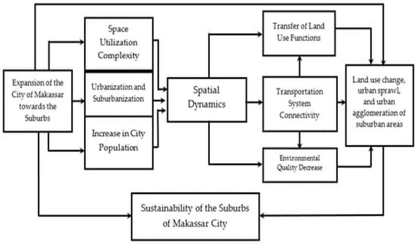
Fig 2: Conceptual framework of urban sprawl and land-use change
Studies show 44% of Londoners inhabit pollution-exceeding zones as congestion rises, directly linked to suburbanization and commuting norms [7]. Additionally, impervious surfaces spike runoff and flood risks, as seen in the Thames 2007 flooding, altering hydrological patterns.
Socially, sprawl strains community fabrics. Isolated outer suburbs often lack transportation options, healthcare access, or socialization, fostering exclusion. Extended commutes eat into family and leisure time for peripheral residents, as neighborhoods densify faster than local services can provide, generating dissatisfaction.
Sprawl also widens inequality. The Greater London Authority links low densities with heightened outer borough poverty as inner-city housing becomes unaffordable, forcing lower incomes to deteriorate peripheries [8]. Spatial segregation concentrates disadvantage in marginalized zones, cementing barriers to opportunity.
Economic costs manifest through inefficient infrastructure dispersal, straining municipal finances. Button (2004) estimates English productivity loses £20 billion yearly due to extended commutes and hampered economic activity. However, regeneration activities catalyze local industry and housing affordability. Strategic suburban growth planning can promote employment.
Thus, a balanced approach to sprawl’s effects is required – appreciating localized economic boosts while mitigating societal and environmental burdens. Sustainable planning emphasizing density, public transit, green spaces, and community building is crucial for a resilient, equitable London.
Attempts to model cumulative impacts highlight the sheer scale of sprawl’s multifaceted consequences. Scenario assessments weigh tradeoffs – comparing a compact city approach versus urban periphery expansion. Findings show that 2050 London could save 18,100 hectares of greenbelt land, £2.6 billion in infrastructure spending, and 85 million extra commuting hours yearly through coordinated containment strategies versus unregulated growth [8]. This demonstrative, if theoretical, exercise unveils the exponential burdens of decentralized spread.
Seeking to quantify consequences, regression analyses unveil statistically significant linkages. As district-level density falls, controlling for income, obesity rates, social isolation, and congestion delays climb. Sprawled environs seemingly discourage active lifestyles and community cohesion while enabling car dependence. However, indicators can show marked improvement where robust public and green space access counters the density drop. Thus, basic accessibility infrastructure alongside considered urban planning proves vital.
Cost-benefit studies also highlight economic tradeoffs. While suburbanization facilitates cheaper housing initially, life-cycle analyses reveal the long-run burdens of maintaining horizontally dispersed infrastructure. Yet market failures often obscure such truths- developers seek quick returns while municipalities inherit future liabilities. Thus, policy interventions like impact fees and urban growth boundaries aim to curb the hidden costs of endless expansion. Evidence shows fiscal sustainability and regional competitiveness rely on balanced, astute growth management.
Hydrological studies led by Mitchell track soil sealing through suburban build-out, quantifying stormwater runoff and groundwater recharge rates affecting downstream discharge and flood risks. As rural catchments urbanize, infiltration falls up to 50% compared to woodland baselines. However, site-level green infrastructure adoption can offset effects, offering ecological engineering pathways within growth. Attentive planning and design protect critical water systems.
Fiscal analyses uncover hidden taxpayer liabilities from horizontal expansion reliant on extending hard infrastructure continuously rather than densifying within serviced bounds. Dispersed patterns multiply costs for communities by up to 25% over more centralized archetypes. Yet once locked in, dismantling roads or pipes proves impossible, suggesting early interventions hold significance before compounding path dependencies.
Psychological dimensions of sprawl show, counterintuitively, tenuous links between low-density surroundings and mental health gains, contradicting stereotypes about suburbia’s tranquility. Studies on attention restoration expose fractured street patterns that induce stress through excessive navigation decision points, whereas cohesive walkable communities promote cognitive calm. Simply correlating houses and happiness overlooks structural design and accessibility variables influencing well-being.
Different Perspectives and Debates Surrounding Sprawl Management
Varying visions collide regarding London’s expanse, making unified sprawl management approaches impossible. The issue is balancing priorities. Proponents advocating compact city models like Thomas Leirvik champion density, mixed zoning, and robust public transport to minimize cars and nurture walkability and sustainability [9]. Research also shows compact cities emit significantly less greenhouse gases. This approach aims to improve efficiency and livability through concentrated development.
Contrastingly, others, including Cheshire, argue for market-driven planning enabling degrees of sprawl to promote affordability. Studies by Glaeser and Kahn indicate cities exhibiting economic and employment gains with tempered sprawl [10]. Supply regulation risks constraining growth by limiting housing based on restrictive zoning rather than demand.
Additionally, sociocultural dimensions matter. Critics like Massey warn of exclusionary sprawl concentrating affluence peripherally while inner-cities sink into poverty, disconnecting communities and embedding inequality. Conversely, N Smith highlights East London’s regeneration, uplifting downtrodden areas with housing and jobs [11]. This underscores place-based and community-focused sprawl management. Regeneration brings opportunities alongside gentrification.
Debates continue regarding feasibility and acceptance. While benefits of density hold merits theoretically, resident opposition to such plans may arise, requiring communication strategies to enable progress and overcome reluctance through early consultation [11]. Balancing perspectives and priorities is essential for effective solutions that account for environment, equity, and economics. Adaptive planning incorporating multiple views can move London towards sustainable and harmonious urban growth.
Moderates seek to reconcile complex sprawl debates by finding common ground. Rather than dichotomous stances of unrestrained free markets versus restrictive high-density zoning, flexible mixed models can apply. Optimizing emerging planning innovations like form-based codes and transit-oriented developments can enable context-specific solutions. Streamlined approvals for compact building projects alongside minimal density requirements foster agile responses to demand. Market urbanism thus adapts through enabling regulation.
Incorporating local community priorities also bridges divides. Designing choice-rich neighborhood enhancements reflecting resident values avoids one-size-fits-all sprawl mitigation. Enhanced walkability, mixed-use zones, and access to green space have multiple preferences at once [1]. When change proceeds gradually and organically from grassroots dialogue, resistance dissipates. Tailored improvements enhance place quality and sustainability simultaneously.
At higher levels, regional coordination introduces efficiencies. Information sharing across municipalities prevents contradictory policies, enabling collaboration on transportation corridors and watershed-scale ecology. Pooling resources also help smaller townships afford progressive land use planning. Partnerships across communities affected by shared sprawl dynamics give voice to participants through a polycentric approach. Concerted efforts empower proactive responses.
Urban growth boundaries attempt to contain sprawl through mandated densification inside delimited edges. Nelson et al. examine boundary outcomes, finding success in limiting geographic leapfrogging into peripheries but failure in fostering affordable housing, illustrating containment tradeoffs [12]. Critiques argue coercion risks overpricing dwellings by capping supply and stifling market freedom. However, evidence shows that smart interventions balancing growth management with equity development prove possible.
Technology optimists envisage algorithmic platforms balancing urban objectives like sustainability, economic dynamism, and inclusion through data integration and predictive modeling capabilities. Genome theory applied to cities aims to decode complex interdependencies for calibrated policy design. Such artificial intelligence systems holding public values could automate zoning provisions, simulating iterative improvements. Technology expands governance toolkits managing multifaceted urban challenges like sprawl.
Theoretical Frameworks for Understanding Sprawl
Beyond statistics, unraveling tangled sprawl forces requires theoretical lenses exposing influential currents subtly shaping complex phenomena manifesting distinctly across London’s physical landscape over the centuries. In this realm, an intricate tapestry of frameworks emerges, each spotlighting unique angles of interplay between spreading expansion and multifarious effects.
Neoclassical economics theory casts sprawl as a market-driven outcome of maximizing personal utility and profits via cheaper peripheral land. Research by Glaeser and Kahn adheres to this model, suggesting that calculated degrees of sprawl can enable economic dynamism and employment [10]. Unfettered suburbanization facilitates efficiency through competitive housing development meeting demand.
In contrast, critics like Harvey insist political ecology better encapsulates sprawl’s nuances, including embeddedness in unequal power structures. This thinking rejects purely market-based logic as frequently advantaging elite interests by marginalizing lower-income groups to inadequately serviced sprawl frontiers. Such studies illuminate sprawl’s role in environmental injustice. Zoning policies and planning processes influenced by the affluent can deepen spatial inequality.
Newman championed urban metabolism as an emerging framework, viewing cities as organisms with inputs, outputs, and waste flows [11]. Through this lens, sprawl constitutes metabolic inefficiency via increased transportation emissions, energy usage, and land degradation, as demonstrated in research by Terrible et al. [13]. Such thinking shines a light on ecological vulnerabilities related to climate change resilience. Rapid horizontal expansion undermines sustainability by heightening resource depletion and carbon impacts.
Sociocultural urban studies invite examining sprawl’s effects on community, identity, and place attachment. Researchers explore related questions of social fragmentation and isolation in sprawling suburbs. This demands efforts to nurture connectivity and belonging amidst decentralized neighborhoods through local community-building initiatives.
Governance frameworks spotlight institutional decision-making processes shaping urban form over time. Examining complex dynamics between policies and economic forces influencing development is important. Coordinating governance mechanisms across scales enables effective sprawl management.
In practice, integrating multiple frameworks informs robust understanding. Planners weigh economic cost-effectiveness against social justice and environmental integrity when charting sustainable growth. Zone permits a balance of developer enthusiasm and local desires via calibrated rules. Each decision reflects layered forces, benefiting from holistic insights.
Attempts to synthesize disciplinary strands into collaborative paradigms highlight interlinkages. New ecological economics combines natural sciences and social analysis to decision frameworks encompassing ecology, psychology, and system dynamics. Similarly, political ecology and social metabolism fuse environmental and urban research traditions. Blending knowledge domains unveils policy levers across dimensions.
Critiquing mono-disciplinary tunnel vision also strengthens comprehension. As philosophers posit, just as five blind sages grasping different elephant parts miss the full picture, singular schools of thought reduce complex realities like sprawl. Planning based solely on economic models ignores social realities. Design thinking lacking quantitative grounding grows speculative. Rigor and relevance intertwine for rounded revelation.
Thus, multifaceted perspectives unveil sprawl intricacies, enabling response agility. Theoretical pluralism powers reflective practice. With insights from economics, ecology, sociology, and applied fields fused into adaptive governance, progress follows.
Methodology
Unraveling the intricate tapestry of London’s sprawl demands a multifaceted approach – weaving together quantitative data analysis and qualitative insights from lived experiences of communities shaped by sprawling dynamics. This methodological framework illuminates complex drivers, consequences, and solutions for this entangled urban phenomenon. Diverse research strands intertwine through triangulation toward holistic comprehension.
Citizen Surveys and Interviews
Central to the research lies direct engagement with Londoners through carefully designed citizen surveys distributed online and in communities representing a socioeconomic cross-section. Questionnaires and follow-up semi-structured interviews gather data across three domains:
Perceptions of sprawl manifest differently based on neighborhood, income, and mobility patterns. Surveys assess subjective viewpoints on issues like environmental impacts, housing affordability changes, and infrastructure pressures from a resident standpoint. Variations in opinion highlight intra-urban divergence of realities within a shared citywide context. Interview narratives then add nuance through personal elaboration.
Lived experiences of sprawl reveal grounded insights beyond statistics on fragmented green spaces or congestion metrics. Questioning documents accessibility challenges, displacement worries, and isolation feelings rooted in the everyday. Comparing outer suburb and inner city views avoids assumptions and over-simplifications regarding a monolithic condition of “sprawl.”
Preferences and proposed solutions indicate public openness to policy interventions to sustainably steer growth. Tradeoff weighing provides pointers for priorities and feasibility constraints around mixed zoning, densification, transit expansion, or conservation initiatives. Receptiveness measures aid realistic goal-setting. Throughout qualitative dialogue builds context and direction.
Spatial Analysis Using Geospatial Data
Geographic information systems provide a visual frame for tracing sprawl’s evolving spatial imprint on London’s landscape. Historic map regressions unveil urban extents over time, quantifying encroachment trends in surrounding counties. Land use classification via satellite imagery exposes neighborhood-level granular transformations– revealing fragmented forests, infill developments, and phases of housing conversions tied to market shifts. Comparison with socioeconomic datasets exposes distributional winners and losers.
Network analyses track infrastructure history – evolution from compact, walkable Victorian urban cores to low-density and sparse outer rings enabled by rail, highways, and utility mains stretching over generations. Morphology metrics show the decentralizing structure as fractal patterns replace concentric circles. Aligning old boundaries and emerging clusters pinpoints growing polycentricism and mobility dependencies undergirding modern spatial patterns.
Spatial regression tools clarify multivariate relationships of sprawl. Isolating the independent influence of transit access or green space proximity on active transport modes provides policy guidance. Likewise, disentangling densities’ effect on social cohesion and housing affordability guides planning tradeoffs. Geospatial models distill complex dynamics with rigor and nuance.
Governance Analysis Using Official Records
While spatial data exposes physical changes over decades of London’s development, the underlying governance backdrop reveals associated decision-making. Tracing policies, plans, regulations, and infrastructure investments from historical archives shows institutional priorities balancing environmental, social, and economic aims across eras. Persistent tensions become visible between suburbanization demands and conservation voices.
Text analysis of zoning codes and ordinances maps out shifting rules of expansion. Qualitative assessments decode political discourses justifying land use laws. Governance frameworks explain the expanding urban scope through permitted development scales and transport investments to enable access. Analysis asks who benefits from associated patterns. Connecting past planning rationales with spatial outcomes builds accountability.
Assessing the strengths and weaknesses of governance approaches requires benchmarking. Comparing strategic plans and investments with peer cities via performance indicators highlights transferable strategies. Synthesizing best practices in participatory planning, transit financing, density bonuses, and conservation zoning refines the London toolkit. Adaptive governance for dynamic urban contexts relies on multi-city insights.
Case Study Investigation of Stratford, East London
An in-depth Stratford case investigation centered on surveys, focus groups, and stakeholder evidence contextualizes sprawl’s drivers and consequences. As an industrial area turned neglected post-war, then the site of Olympics investment and intense regeneration, citizen memory maps emotional attachments to place amidst profound change. Shared community assets like markets and green spaces anchor identity beyond housing turnover. Discussions probe who won and lost from area upgrading.
The voices of long-term Stratford inhabitants reveal generational place change effects in grounded detail. Comparing experiences via oral histories builds a nuanced understanding of social exclusions and barriers that can accompany even well-intentioned development schemes. Class and ethnic dimensions of neighborhood transitions become clearer. Lasting policy insights stem from listening to marginalized groups.
Infrastructure and built fabric changes since 1900 emerge through archival records and aged mappings. Past transport access and land use shape present conditions- inertia resists radical shifts even from ambitious renewal initiatives like the Olympics. Therefore, change often occurs more organically from grassroots demands than top-down targets. Local empowerment enables sustainable development too.
Data Analysis Using Mixed Methods Approach
An interdisciplinary analytical approach befits sprawl’s complexity, integrating statistics, spatial metrics, textual assessments, institutional analysis, and qualitative insights via mixed methods. Coding interview transcripts elicit common themes of identity, accessibility, and environment. Comparing subjective attitudes, geospatial mappings and policy documents either corroborate or reveal contradictions between infrastructure delivery, ecosystem changes, and community feelings. Multi-angle triangulation sharpens conclusions.
Quantitative spatial data converted into indicators tracking land use mixes, transportation diversity, housing densities, and social equity over time measures objective phenomena often discussed abstractly. Temporal analytics determine whether perceptions of accelerating unsustainable resource demands match empirical records or stem more from nostalgia or aesthetic critiques. Big data injection quantifies the backdrop framing individual opinions.
Similarly, statistical survey analysis tests preconceptions around mobility practices. Stated preferences for transit investment may contradict actual ridership metrics dependent predominantly on car infrastructure inertia. Revealing such nuances informs policy targeting. Open answers code into narrative categories explaining personalized infrastructure access barriers, cross-checked through spatial proximity mapping to pinpoint exclusion hotspots demanding priority interventions.
Integrating governance archival research, physical analytics, community insights, and statistical generalizability enables well-rounded scholarship. An interdisciplinary mixed methodology leverages strengths across academic tribes to address multidimensional 21st-century urban challenges.
Ethical Considerations
Research rigor intertwines with ethics. Voluntary participation via signed consent forms precedes all surveys and interviews, with confidentiality safeguards built into anonymous data reporting. Representing comments accurately comes foremost, as well as recognizing vulnerabilities around housing security or immigrant status expressions. Cross-checking draft findings with participants establishes truthful communication. Data licensing forbids commercial usage while enabling academic scrutiny and non-profit redistribution.
Beyond procedural codes, the research holds itself accountable to social and environmental justice principles through consciously inclusive approaches. Active targeting engages marginalized demographic groups, enabling trust-building that overcomes power barriers hindering honest participation. Discussing provisional results reciprocally empowers recipients as mutual knowledge producers rather than passive subjects. Intentional designs reduce inequalities.
Throughout, sustainability guideposts prevent exaggerated claims or selectively dire interpretations from fueling excess anxiety, which is counterproductive to constructive progress. Systemic analyses integrate longer-term cyclical dynamics, avoiding reactionary conclusions. Implications target resilience strategies over stabilization quick fixes. Interdisciplinary balance grounds messages conveying complex challenges. The methodology aligns reliability and transparency with social responsibility.
This multifaceted framework combines surveys, analytics, archival research, and in-depth place-based insights to illuminate the intricate forces entangling London’s uneven urban growth. Quantitative and qualitative strands interlace towards holistic comprehension. By centralizing community experiences alongside geospatial data within a political-economic context, the approach shines a light on drivers and consequences shaping localized spaces through sprawling urbanization processes. The methodology consciously builds collective urban knowledge to nurture policies for just sustainability.
Case Study – Stratford, London
In East London’s Newham borough, Stratford stands today as a vibrant tapestry woven from threads of industrial heritage, regeneration-induced transformation, and ongoing adaptation. Its historical trajectory reveals physical evolution and the dynamic interplay between economic forces, community resilience, and shifting sprawl realities.
Anglo-Saxon settlements predated 12th-century abbey lands, shaping centuries of agricultural usage before 19th-century industrialization catalyzed village growth into a bustling manufacturing hub as rail links drew investments. By the late Victorian era, industrial sprawl characterized Stratford amid terraced housing and steam factories employing generations of working-class residents.
As London spread eastwards, suburbs consumed rural Stratford through the early 20th century, bringing a mix of opportunities and challenges. While economic prospects beckoned, cramped housing, congestion, and pollution emerged. Still, the town retained its vibrancy through landmarks like Theatre Royal Stratford East (1896), fostering community identity amidst fast-paced change.
Post-war decades brought decline as industries moved. Shipyards closed, warehouses emptied, and jobs vanished, leaving derelict infrastructure piercing the landscape. And yet, resilient roots held firm. Grassroots conservation societies coalesced, protecting heritage sites and nurturing partnerships for area revitalization before top-down initiatives later took shape.
The unveiling of London’s 2012 Olympics in Stratford announced a pivotal turning point. Overnight, global attention and massive public-private investments poured into the district, promising regeneration. The construction of gleaming sporting facilities and sparkling high-rises delivered tangible physical transformations to the once-downtrodden industrial zone.
Undoubtedly, the Olympics brought stratospheric changes to Stratford, practically and psychologically. And yet, complex realities accompanied revivalist rhetoric. Influxes of professionals and commuter flats sparked worries of cultural erasure and cost of living spikes. Previous residents faced anxieties about being left behind or displaced through gentrification dynamics concentrating on commercial wealth. Still, many hoped for sustained opportunities.
Today’s Stratford weaves old and new through its patchwork of punk music pubs and polished shopping centers. History collides with modern demands in an area grappling with balancing economic uplift, habitability, and inclusion. Lessons for sustaining regeneration shine through about privileging people’s well-being equitably in place of change. As forces of development press on, Stratford’s story continues unfolding.
Causes and Effects of Sprawl in Stratford
Behind Stratford’s shape-shifting urban landscape lie intricate sprawl forces and consequences – a microcosm where threads of housing markets, transit access, environmental stress, and social impacts intertwine.
Housing Dynamics Shaping Development
Real estate markets stirred dramatic physical upheaval in Stratford during recent decades. Olympic investment sparked a wave of upscale apartment blocks catering to young professionals and commuters. While expanding housing access and local growth, critics worried effects priced out longer-term working-class inhabitants lacking protections from gentrification [14]. Analyses reveal gaps widening between incomes and housing costs as areas upgrade, with ripple displacement effects.
Mobility Infrastructure Influence on Land Use
Transport history shaped Stratford’s form too. Industrial-era railway siting concentrated Victorian factories and dense worker cottages here originally. Yet car-centric planning enabled later decentralized sprawl creep facilitated via highways [15]. Recent upgrades through new stations and the Queen Elizabeth line expanded transit access. This improved connectivity supports ongoing development by drawing more commuters. However, car ownership remains high locally, constraining sustainability.
Fig 3: Urban regeneration in Stratford
Environmental Implications of Changing Land Uses
With densification and demolition/construction disturbance, environmental issues grew locally. Losing green cover contributes to heat exposure and air pollution on local and global scales. Researchers highlight the need for green space integration in planning to support ecological equilibrium and community health through vegetation and permeable surfaces [14]. Sustainable buildings incorporating energy efficiency and rainwater harvesting offer Stratford opportunities to mitigate the impacts of regeneration.
Social and Economic Impacts on Community
Through changing demographic mixes and increased costs, longtime residents faced access barriers to local housing and shops from gentrification dynamics. While recognizing economic boosts from renewed interests, ensuring participation by marginalized groups in planning processes promotes accountability to existing communities. Studies highlight priorities around affordable options, small business sustainability, school upgrading, and collaborative local decision-making so regeneration nurtures cohesive, resilient neighborhoods rather than exacerbating divides.
In essence, unpacking sprawl complexities in Stratford showcases the interlaced factors propelling uneven development. By understanding interconnected housing, mobility, environmental, and social tradeoffs exemplified in regeneration areas, planners can chart courses supporting holistic habitability, sustainability, and inclusion as districts evolve.
Solutions and Mitigation Strategies for Managing Sprawl in Stratford and Beyond
Stratford’s turbulent relationship with sprawl offers takeaways for growth management inside and beyond London. Lessons highlight balancing priorities across dimensions:
Centering Sustainability in Development
Compact building proves integral through infill housing near mixed-use transit hubs rather than continuing horizontal spread. Density in design accommodates units while integrating green spaces for ecological and social benefits. Stacked formats reduce land take. Shifting car-reliance, cycling, and walking infrastructure alongside accessible public transport options alters mobility assumptions, enabling non-motor movement. Upfront sustainability investments save for a long time.
Fostering Inclusion Through Holistic Planning
Inclusive communities necessitate meaningful participation and affordable housing access. Concerted policies like municipal housing trusts overcome gentrification exclusion through below-market units reserved for vulnerable occupants by subsidizing rents perpetually. Balloting prioritizes longstanding locals [16]. When marginalized groups steer dialogue, positive place visions emerge. Co-creating plans with people forges collective purpose and care for residents through quality service provision.
Fig 4: Sustainability
Coordinating Governance Across Jurisdictions
Fragmented authorities control components of infrastructure and land uses, causing piecemeal development or contradictory aims without coordination. Regional partnerships enable cohesive transit by linking train and bus networks across districts. Data sharing also prevents overlapping or absent services via participatory sensing, showing crowdsourced infrastructure gaps, flooding hazards, or mobility barriers. Recognizing sprawl transcends municipal boundaries unifies responses.
Cultivating Local Pride and Participation
Community identity cultivates grassroots movements for justice and environmental dignity. Art initiatives celebrating cultural heritage strengthen ties between generations through common places as benchmarks of continuity amid physical flux [16]. Showcasing unique ecological habitats also builds public awareness and willingness for stewardship initiatives to improve local nature. Active improvement follows when residents connect with changing locales rather than retreat into nostalgia.
Integrating Green and Blue Infrastructure
Hard engineering approaches falter against complex urban challenges without working along nature’s grain. Holistic landscape designs regenerate degraded hydrology and microclimates towards functioning green and blue networks threading through communities. Bioswales along sidewalks and parks cleanse stormwater runoff, mitigating flood risks through absorption and filtration to replenish aquifers [17]. Meanwhile, rewilded green corridors reconnect fragmented habitats, reviving biodiversity resilience and ecological balance.
Retrofitting Urbanism for Pedestrian Friendliness
Car-centric urban textures impose barriers to sustainable community building yet demonstrate path dependence and inertia. Retrofit interventions like scrambles, curb extensions, and ramps reclaim street space from vehicles for play and lingering. Tactical urbanism approaches trial modifications at low cost to demonstrate desirability for permanent upgrades over time. Phased flexibility futureproofs neighborhood liveability amid uncertainty.
Encouraging Communal Transit and Mobility Sharing
Mobility gaps require solutions through shared platforms that match supply and demand dynamically to enable car-free lifestyles. Community vanpools and non-profit bike-share systems bridge distances unsupported by mass transit. Meanwhile, micromobility options like e-bike pools promote post-car freedom. App integration assists multi-modal transport. When low-cost collaboration replaces isolated ownership models, sustainable access unlocks economic advantages too.
Building A Climate-Resilient Future
With climate uncertainty ahead around increasing storm severity and urban heat, resilience preparation saves lives and money. Participatory risk mapping engages locals in constant emergency response while identifying chronic hazard zones for preventative investment, like floodable parks or air conditioning centers. Future-scoping simulations calculate extreme weather cost scenarios to motivate energy transitions and contingency infrastructure. Being change-ready spares suffering when events unfold.
Policy Packages for Positive Change
Technical solutions flounder without supportive institutions and regulations. Groups like New Homes London advocate for change locally while enabling replication elsewhere. Platforms align resident campaigns, industry pioneers, and officials to lobby for sustainability mandates [18]. Successful grassroots packages catalyze change by demonstrating wide buy-in, garnering political attention for issues like natural space quotas in masterplans or low-energy building codes, and raising standards over time.
With multiple priorities at stake, managing sustainable and inclusive growth in shifting communities like Stratford relies on balanced policies attuned to local realities, coordinated governance enabling participation, accessible infrastructure for holistic habitation, and ecological regeneration towards district and regional resilience over time. As threads weave together, creating sturdy fabrics, interlaced initiative strands foster equitable urban habitats where communities flourish in the face of sprawl’s complex changes.
Conclusion
Navigating London’s intricate sprawl drivers and consequences provides illuminating insights. Research interweaving surveys, spatial analysis, governance traces, and targeted case studies reveals economic forces, community identities, and physical manifestations sculpting uneven urbanization. Stratford crystallizes multifaceted change dynamics. We witness industrial roots spur initial growth before decline struggles. Yet revival emerges through contested sustainability visions debating local to global tradeoffs.
Stratford signals priorities: Holistic planning integrating resilient built environs and participatory processes for equitably sharing benefits of change; Polycentric governance and grassroots leadership for nurturing community fabrics within global forces; Accessible infrastructure enabling low-carbon lifestyles; Nature restoration fostering long-term ecological habitation amidst density. Lessons resonate beyond single sites.
Furthermore, the research demonstrates that sustainable and just futures rely on balanced, adaptive policies responding to integrated insights. Key conclusions include the needs for:
- Smart development promoting density, alternative transit, and greening to mitigate hazards of unrestrained sprawl. Compact, mixed-use growth bounds land expansion, enabling low-carbon mobility.
- Inclusive regeneration avoids displacement of marginalized residents through affordable housing provisions and grassroots involvement in local decision-making.
- Regional coordination via partnerships on transport, data sharing, and watershed ecology to enable harmonious development.
- Public participation and education engaging communities in steering local enhancements for contextual fit and grassroots buy-in.
London’s complex urban spatial mosaic offers lessons encapsulating global phenomena through long local histories. By applying insights around integrated infrastructure and governance advancing equity and sustainability, London can transform uneven geography into adaptability for thriving communities despite uncertainties ahead. The future remains unwritten, pathways unforetold; direction relies on decisions elevating inclusion and resilience.
References
[1] L. l., “Urban sprawl in provincial capital cities in China: Evidence from multi-temporal urban land products using Landsat data. Science Bulletin,” Sci. Bul, vol. 64, no. 14, pp. 955-957, 2019.
[2] K. Stanilov, “Planning the growth of a metropolis: Factors influencing development patterns in West London,” Journal of Planning History, vol. 12, no. 1, p. 1875–2005, 2013.
[3] A. C. J. E. P. Monkkonen, “Urban sprawl and the growing geographic scale of segregation in Mexico,” Habitat International, vol. 73, no. 4, pp. 89-95, 2018.
[4] J. K. M. K. SE Bibri, ” Compact city planning and development: Emerging practices and strategies for achieving the goals of sustainability,” Developments in the built environment, vol. 85, no. 6, 2020.
[5] G. M. E. V. A. G. K Lucas, “Transport poverty and its adverse social consequences,” Proceedings of the institution of civil engineers-transport, vol. 169, no. 9, 2016.
[6] GLA, ” London’s State of Green: Environment,” GLA, 2015. [Online]. Available: https://www.london.gov.uk/programmes-strategies/environment-and-climate-change. [Accessed 23 01 2024].
[7] GLA, ” London Ambient Air Quality Monitoring Network,” Greater London Authority, 2019. [Online]. Available: https://www.londonair.org.uk/LondonAir/General/about.aspx. [Accessed 23 01 2024].
[8] GLA, “The Economics of London’s Environmen,” Greater London Authority, 2016. [Online]. Available: https://www.london.gov.uk/programmes-strategies/research-and-analysis/gla-economics-publications. [Accessed 23 01 2024].
[9] P. O. T. L. SA Sarkodie, “Global effect of urban sprawl, industrialization, trade and economic development on carbon dioxide emissions,” Environmental Research, vol. 15, no. 3, 2020.
[10] M. K. EL Glaeser, “Sprawl and urban growth,” Handbook of regional and urban economics, 2004.
[11] N. Smith, The new urban frontier: Gentrification and the revanchist city, Taylor Francis, 2005.
[12] R. P. C. D. G. K. AC Nelson, The link between growth management and housing affordability: The academic evidence, seattlebubble.com, 2001.
[13] L. C. M. A. L. Y. S Derrible, “Urban metabolism,” Urban informatics, 2021.
[14] R. Ewing, “Characteristics, Causes, and Effects of Sprawl: A Literature Review,” An international perspective on human interaction, pp. 519-535, 2008.
[15] BBC, “Urban change in the UK,” BBC, 2023. [Online]. Available: https://www.bbc.co.uk/bitesize/guides/z9y47hv/revision/3. [Accessed 23 01 2024].
[16] J. R. J. J. J. J. J. J. J. Song, “Techniques for mitigating urban sprawl: Goals, characteristics, and suitability factors,” Work, vol. 4420, no. 1, 2002.
[17] S. H. K. K. R Paterson, “Techniques for mitigating urban sprawl,” CR Bhat, vol. 4420, no. 2, 2003.
[18] H. Ismael, “Urban form study: the sprawling city—review of methods of studying urban sprawl,” Geo journal, vol. 86, no. 4, pp. 1785-1796, 2021.
 write
write